The bigger picture
Author: Shannon de Roos, PhD student at KU Leuven
Agricultural productivity has vastly increased over recent decades as agricultural technologies have improved. However, future challenges such as population growth, land degradation and climate change mean that agricultural systems will have to keep adapting. Assessing the impacts of these global issues requires larger-scale perspectives rather than measurements within individual farmer’s fields. Work Package 3 (WP3) of the SHui project therefore assesses crop development over a regional to continental domain at a relatively high resolution (~1km). Thanks to the increasing availability of high resolution spatial data and enhanced computer systems, new possibilities in agricultural research can be explored at various scales.
During my Earth Science (BSc) and Physical Geography (MSc) degrees, I learned about surface and subsurface hydrological processes, land degradation, and how to work with various software and models. I have also done fieldwork in various countries and worked with other researchers, farmers, environmental agencies and meteorologists. My PhD research within SHui allows me to combine all these experiences and apply them to a more technical field of Geosciences. It has been a challenging but rewarding trajectory, with a very steep learning curve.
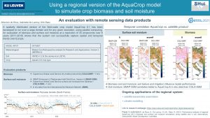
My research consists of two main parts. Initially, I developed and evaluated a spatially-distributed version of the field-scale AquaCrop model version 6.1. This regional version wraps AquaCrop in a parallel processing system, to make it run efficiently for any given resolution and domain. Various satellite products were used to evaluate biomass and surface soil moisture, with the findings recently submitted to the peer-reviewed journal Geoscientific Model Development.
Currently, I am applying satellite-based data assimilation to the AquaCrop model to improve the model simulations. For this, I use the Water Cloud Model to translate AquaCrop soil moisture and vegetation output into backscatter values, which are measured by active microwave satellites such as Sentinel-1. I will present preliminary findings at the IGARSS conference in Brussels in July. I am excited to work on this new topic, with the support of a research team that has much experience in Data Assimilation.
My overall aim is to build a robust and reliable spatially distributed version of AquaCrop, which can be applied to any region and for any crop type. I hope this spatial version of the model will provide more insight into regional changes of biomass production and soil moisture trends over time.
I’ve recently launched a new research webpage (https://ees.kuleuven.be/project/shui-regionalaquacrop) and gave a 2-minute virtual PICO presentation at EGU 2021 conference (see poster in Fig.1.). I consider myself lucky that COVID hasn’t affected my research, but I do look forward to the first conference that will be live again.