Work Plan
SHui foresees activities over 4 years arranged in 7 work packages (WPs), whereby:
- WP1-WP4 are Research+ Development+innovation (R+D+i) related.
- WP5 will provide the socio-economic dimension.
- WP5-WP6 will disseminate innovation to stakeholders and communicate to society.
- WP7 manages the project.
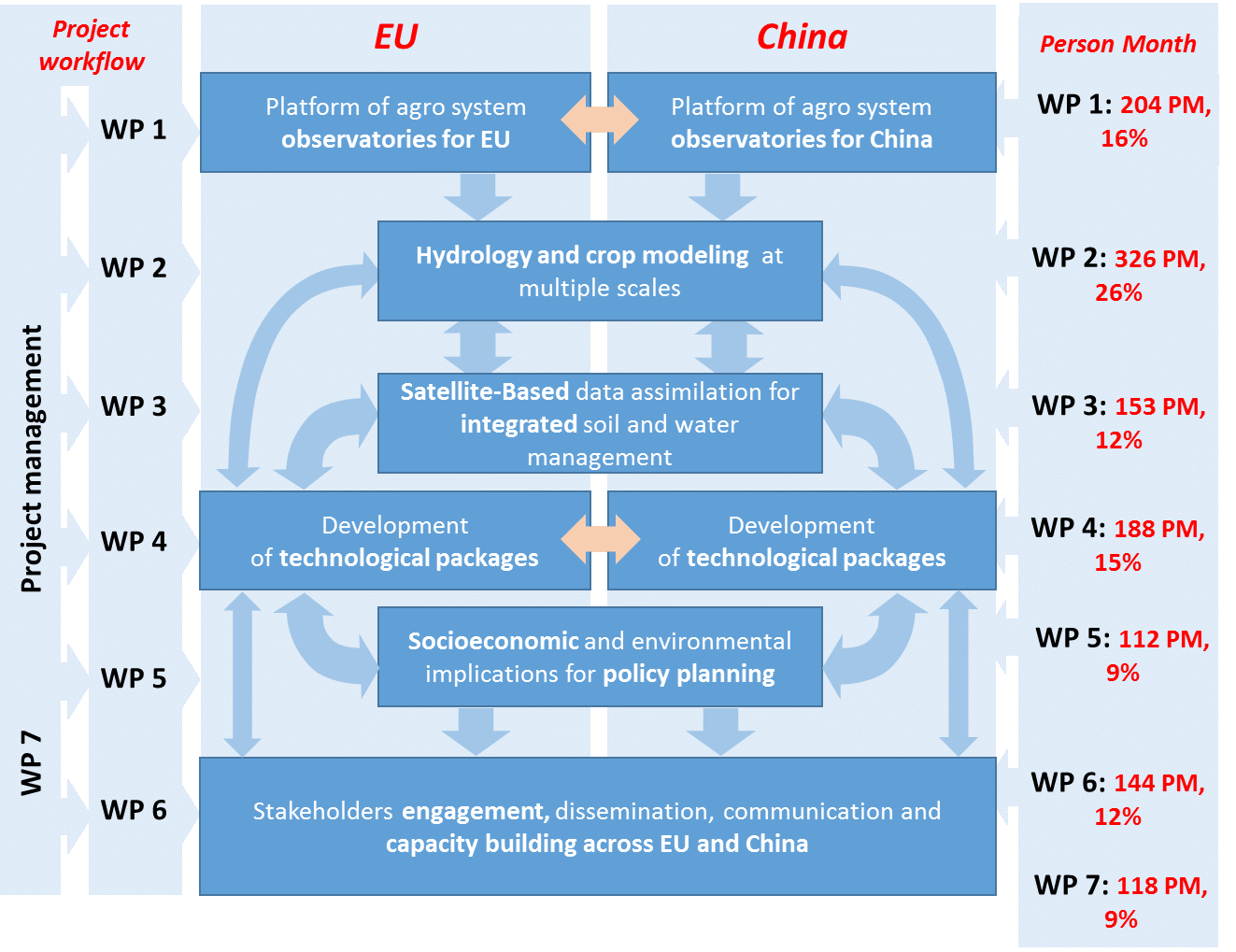
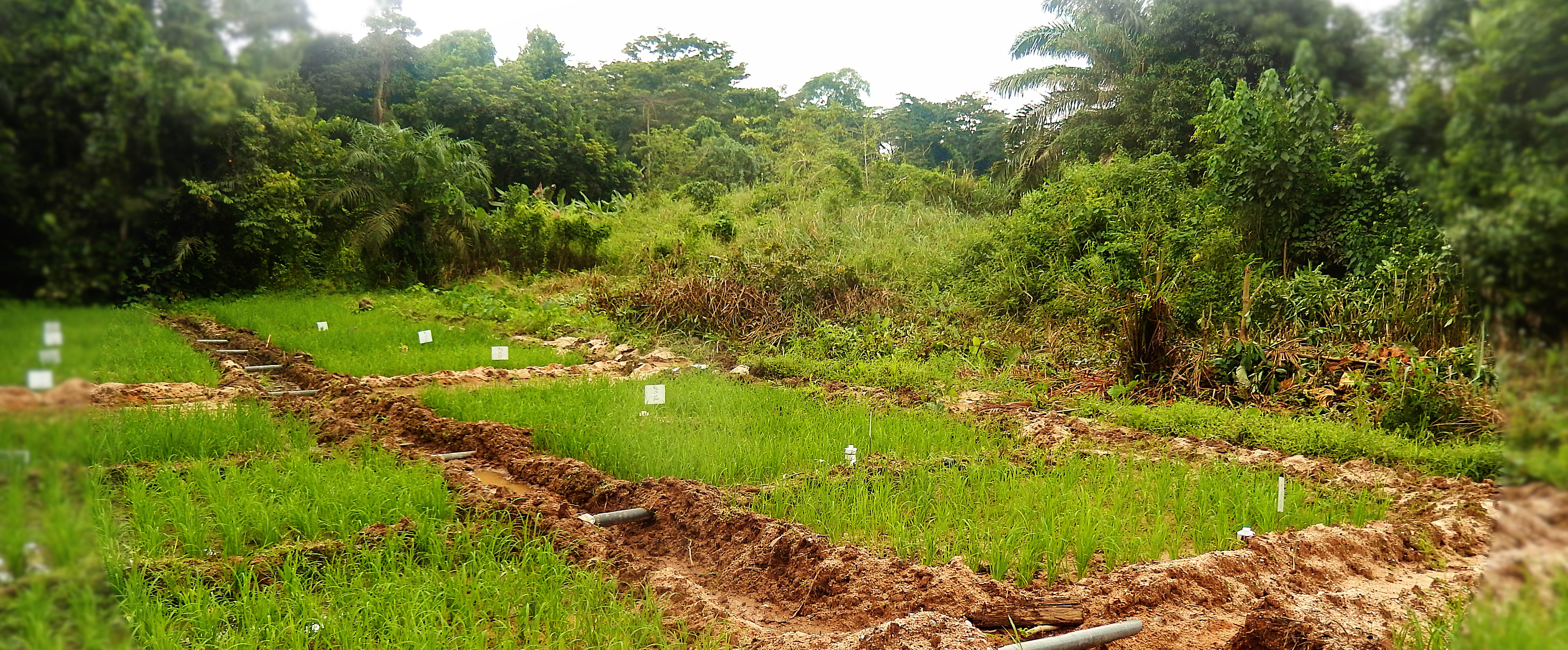
WP1. Research platform of agrosystem observatories for benchmarking, modeling and training.
Leaders: Andreas Klik (BOKU, Austria) & Xingmin Mu (Northwest A&F University, Yangling).
WP1 will ensure different experiments operate as a research network to compare and contrast the effects of different interventions. WP1 will (1) Develop an open-data platform for sharing long-term data on crop development, crop yield, soil properties/quality, water quality and climate. (2) Validate/integrate the best practices developed by WP4 within the long-term experiments (3) Establish benchmarks for water use and delivery of agro-ecosystem services.
WP1 will provide data from the long-term experiments in a consistent format to WP2 to facilitate crop growth and hydrological modeling, and data used in the development of decision support systems by WP4. WP1 will also provide ground-truthed data for validating the large regional modeling in WP3, and information used by the socioeconomic analysis of WP5. Some of the field experiments will also be used as host sites for the capacity building actions of WP6.
WP2. Hydrology and crop modeling.
Leaders:
WP2.1: Elias Fereres (UCO, Spain) & Qiang Zuo (China Agricultural University).
WP2.2: Tomas Dostal (CVUT, Czech R.) & Honghu Liu (Changiang River SRI).
This WP is subdivided into two intertwined sub-WPs, WP2.1. Crop modeling and WP2.2. Hydrology and soil erosion modeling.
WP2.1 will evaluate the crop response to different water availability under irrigated and rainfed conditions by:
- Calibrating the current generation of AquaCrop with data from long-term experiments.
- Coordinating the development of specific elements within AquaCrop for situations key to cropping under water scarce conditions.
- Developing a hybrid-type model to simulate yield responses of tree crops to variable water supply.
- Integrating the crop yield scenarios via conceptual upscaling on a GIS platform for catchment analysis in cooperation with WP2.2.
WP2.2. will model soil water regime, hydrological balance and soil degradation at different scales by: (1) Calibrating the current generation of selected models: RUSLE [28 Dabney et al., 2012]; WATEM/SEDEM, WEPP ; Hydrus, SWAT at plot and field scale (2) Performing catchment analysis including crop yield scenarios using a conceptual upscaling based on a GIS platform (3) Developing in cooperation with WP2.1, an exploratory analysis of fully coupled hydrologic and crop models that link variability of soil properties (related to soil water availability) to yield at field scale.
WP2 will provide model simulations at field and catchment scales (validated from WP1 data) and the results will be used to support satellite based data assimilation at regional scale by WP3. Results from these analysis will be incorporated into the functions used by the decision support systems developed by WP4, and into the integrated socioeconomic and environmental analysis carried out by WP5, and models incorporated into the training activities planned by WP6.
WP3. Satellite-based data assimilation for integrated soil and water management.
Leaders: Gabrielle De Lannoy (KU Leuven, Belgium) & Suang Liu (Beijing Normal University).
WP3 will upscale model outputs over large regional scales by assimilating remote sensing data and other available digital spatial databases into a fully coupled hydrologic-crop growth model. WP2 will:
- Coordinate with WP1 to gain ground-based information for validation of modelling and data assimilation efforts,
- Process remote sensing data to support regional scale estimates of soil moisture, vegetation, evapotranspiration,
- Integrate remote sensing data into a coupled land surface – crop growth model,
- Cooperate with WP4 and 6 in developing protocols and strategies to use at the regional scale, based on scenario analyses. Input data supply for WP2, providing optimal land surface estimates obtained by merging remote sensing data with models at the larger regional scale.
WP3 will provide remote sensing data on soil moisture and landscape structure to WP2 to facilitate crop growth and hydrological modeling. Moreover, results of the large regional assessment will be used in the socioeconomic and environmental analysis done by WP5. Some their results will be used in designing the decision support system by WP4 and in the training and dissemination activities by WP6.
WP4. Development of technological packages for integrated water management.
Leaders: Alon Ben-Gal (ARO, Israel) & Jianhua Zhang (Hong Kong Baptist University).
WP4 will link data to farm and region decision making by:
- Interpreting data/model outputs from other WPs
- Building decision support algorithms based on crop-specific objective functions based on accessible data acquisition, and
- Converting these into practical applications: control measures, techniques, practices and technologies.
WP4 will integrate the findings of WP1, 2 and 3 into the Best Management Practices optimized for specific (economic, social, environmental) impacts, and the accompanying decision support systems which will be disseminated by WP6 and evaluated, in terms of cost/benefits and stakeholder´s willingness to adopt, by WP5.
WP5. Socioeconomic and environmental implications for policy planning.
Leaders: Holger Bergmann (U. Göttingen, Germany) & Funing Zhong (Nanjing Agricultural University).
WP5 will coordinate a trans-disciplinary stakeholder approach on farm and regional scale to:
- Evaluate and construct an adapted cost-benefit analysis of best management on-farm strategies developed within the project which will include specifically social, environment and gender aspects.
- Develop an efficient strategic framework for regional and local allocation of soil and water resources under specific cropping systems including the impact on selected ecosystem services.
- Coordinate and disseminate economic analyses for policy makers and land users using participatory approaches.
WP5 will develop comprehensive environmental and socioeconomic analysis of the study areas. Part of their results will be used in the dissemination and capacity building actions of WP6, provide feedback from the stakeholder´s perspectives on the Best Management practices and tools develop by WP4.
WP6. Stakeholders engagement, dissemination, communication and capacity building.
Leaders: Ian Dodd (U. Lancaster, U.K.) & Zhi-Qiang Zhang (Beijing Forestry University).
WP6 focuses on long-term economic, environmental and scientific benefits of the research by influencing on-farm decision making and regional water policies, dissemination across stakeholders and communication to society. WP6 will:
- Coordinate communications across continents to allow database integration and technology transfer
- Coordinate engagement with local stakeholder groups to understand variable rates of technology adoption linked to WP5
- Assist commercial partners to facilitate technology adoption within the target countries
- Train early career scientists and consultant agronomists in applying technologies
- Deliver research via communications/ publications to a variety of end-users tailoring the message in a gender sensitive way when appropriate.
WP6 will provide information on stakeholder motivations to inform preparation of dissemination materials by WP6 and feedback to WP4 to improve the Best Management Practices and supporting tools in alignment with stakeholder requirements.
WP7. Overall project coordination and management.
Leaders: José A. Gómez (CSIC, Spain) & Weifeng Xu (Fujian Agriculture and Forestry University).
WP7 will manage and coordinate the project, supported by a management team and overseen by an
international advisory board comprising leading international scientists, policy-makers and industrialists. It will ensure that all team members have a common understanding of project progress, outputs, benefits and implications, combining the achievement of the scientific and dissemination objectives with a longer term vision of networking teams and research on soil-water-agronomy at large scale across EU and China for the next decade.